

Driver’s Desk
How to Improve GPS Accuracy for Vehicle Trackers
You check the tracking app and find your parked car sitting half a block away from where you left it. The vehicle hasn't moved, yet the map says it has. That looks like a defective tracker, but the device may be working normally and reporting a position distorted by its antenna placement, satellite geometry, reflected signals, or a blocked view of the sky.
The practical answer to how to improve GPS accuracy starts with separating two problems. Receiver-side issues include mounting location, antenna orientation, firmware, satellite support, and cellular assistance. Environment-side limits include tall buildings, parking garages, metal films, and reflected signals. Fix the receiver-side problems first, then test the tracker in conditions that reveal what the surrounding environment is doing.
Why Your Car Tracker Sometimes Looks Drunk
You open the tracking app and see your parked car sitting half a block away. The vehicle has not moved, yet the map pin has. That does not automatically mean the tracker is defective. The receiver may be reporting a position distorted by antenna placement, satellite geometry, reflected signals, or a blocked view of the sky.
GPS accuracy means how close the reported position is to the vehicle's actual position. It does not promise that the pin will remain on the exact parking space. A consumer tracker can show visible scatter even under good conditions, and the manufacturer's measurement method affects how its accuracy claim should be read.
CEP-50 is the radius containing half of the reported positions. 2DRMS is a wider statistical measure based on horizontal error. These measures are not interchangeable. A tracker advertising a small accuracy radius may be using a different standard from another device. In open sky, consumer devices commonly operate in the 3 to 5 meter range. Severe obstruction or multipath can push errors beyond 10 meters, according to the British Columbia RTK positioning specifications.
A useful reference point is the removal of Selective Availability on May 1, 2000. One study recorded civilian mean location error falling from 23.9 meters to 1.4 meters, while maximum observed error fell from 94.8 meters to 3.1 meters after the change, as documented in the GPS performance analysis. Modern trackers build on that baseline with improved receivers, multiple satellite constellations, correction data, and filtering.
The three errors behind a wandering pin
- Satellite geometry: Satellites spread across the sky give the receiver better angles for calculating position. Poor geometry magnifies small measurement errors.
- Atmospheric delay: Signals slow and change as they pass through the atmosphere. The receiver estimates those effects, but cannot remove every error.
- Receiver noise: Antenna quality, electronic interference, weak signals, and imperfect measurements add uncertainty.
The GPS performance standard sets baseline targets of 8 meters or less horizontal error at the 95% level and 13 meters or less vertical error at the 95% level, with worst-site targets of 15 meters horizontal and 33 meters vertical. Those are system-level limits, not a promise for a tracker hidden below a dashboard.
Installer's rule: If the position improves when the vehicle reaches open sky, investigate the installation and surroundings before replacing the tracker.
A small amount of scatter in trip playback can be normal. Repeated jumps across parallel streets, a stationary vehicle appearing in another block, or updates stopping inside a garage needs diagnosis. The route history view helps distinguish one bad point from a repeatable pattern.
Where You Mount the Device Matters More Than the Model
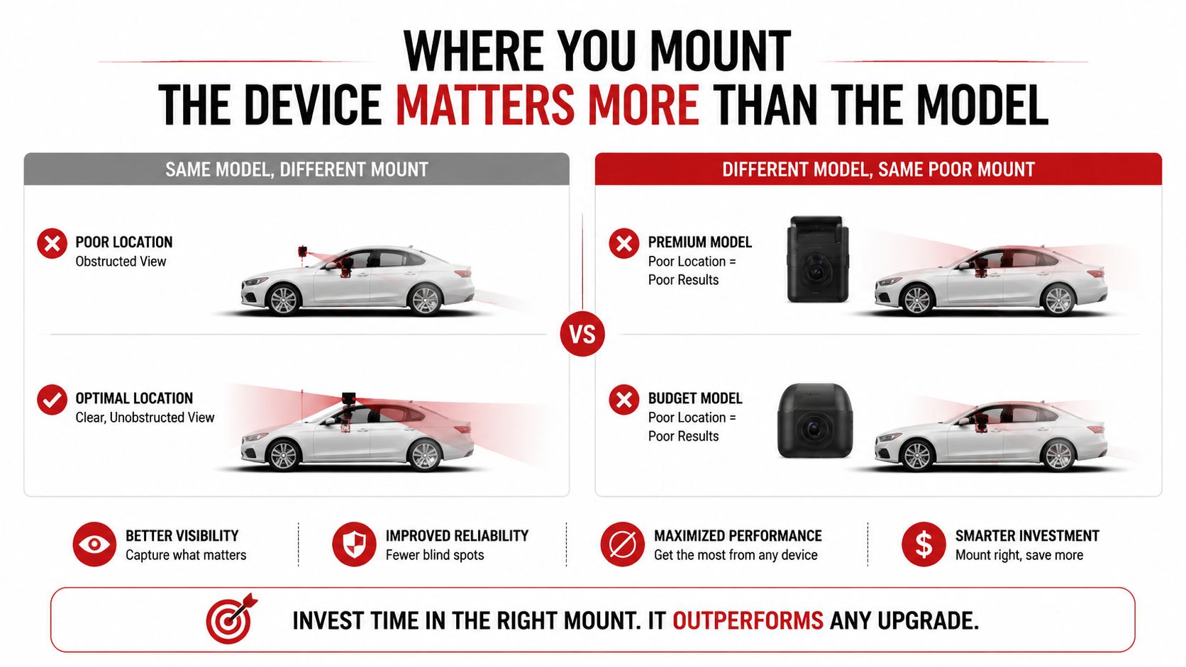
A tracker can have a capable GNSS chipset and still perform poorly if its antenna is facing the wrong direction or buried under signal-blocking material. In vehicle installations, placement often matters more than choosing between two devices with similar receiver specifications.
| Mounting position | Main advantage | Main weakness |
|---|---|---|
| OBD-II port | Fast, simple installation | Low position, dashboard plastic and wiring can obstruct the antenna |
| Hardwired behind the dash or kick panel | Clean and difficult to spot | Concealment usually reduces sky visibility |
| Magnetic puck or upper dash | Stronger view of the sky | More visible and easier for a thief to discover |
OBD-II is convenient, not automatically accurate
An OBD-II tracker sits low in the cabin, often below the steering column. The dashboard structure, instrument cluster, wiring, and trim sit between the antenna and the satellites. It can work well in open areas, but its position gives it less margin when the car enters a street lined with tall buildings.
A hardwired unit behind the dash offers better security and a cleaner finish. The problem appears when an installer pushes it deep behind the fuse box, wraps it in dense material, or places it beside metal brackets. The tracker may still report a fix, but it can use fewer reliable measurements.
A magnetic puck or upper-dash installation usually gives the antenna a cleaner path upward. It also exposes the device, which is a poor trade for a security tracker if a thief can see and remove it. The best installation balances concealment with usable sky view. CarLock's device features guide describes the practical role of tracker hardware, but the physical installation still determines what the antenna can receive.
Point the antenna at the sky
Most GPS ceramic patch antennas work best when the broad, flat face is oriented upward. A horizontal position on a flat upper surface generally beats mounting the device vertically against a seat rail or side panel. If the tracker has an external antenna connector, routing that antenna toward the windshield header can preserve concealment while improving its view.
Avoid predictable trouble spots:
- Rear parcel shelf: Metallic window tint and the body structure can weaken reception.
- Engine bay: Metal surrounds the device and creates a hostile signal environment.
- A-pillar trim: Airbags and structural metal make this an especially poor hiding place.
- Metal enclosures: A metal box can block or distort satellite reception.
- Thick roof areas: Coated panels and embedded vehicle electronics may add attenuation.
The trade-off is straightforward. A concealed tracker is harder to tamper with, but a completely buried antenna can produce unreliable positions. A hidden unit with a remote antenna near the windshield header is often the sensible compromise.
Settings, Firmware, and Assisted GPS You Can Tweak Today
Software changes won't make a physically blocked antenna see through a building. They can, however, prevent avoidable delays and help the receiver use the measurements it already has.
Start with firmware. GNSS firmware controls satellite handling, measurement filtering, constellation support, and communication with the vehicle tracker. An update may address a known reception or reporting fault, so check the manufacturer's app and support page regularly. Don't assume a new phone app automatically updates the firmware inside the tracker.
Turn on the satellite options your hardware supports
Enable multi-GNSS if the device offers it. GPS combined with GLONASS, Galileo, or BeiDou gives the receiver access to more signals and can improve satellite geometry when part of the sky is blocked. The benefit depends on the receiver, antenna, location, and the quality of the available signals. More visible satellites aren't automatically better if reflected signals dominate.
A field test found that SBAS produced better than 1.5-meter horizontal accuracy at the 95th percentile in open areas, while RTK commonly delivered less than 2 centimeters and RTX produced vehicle accuracy of a few centimeters in urban environments, as reported in this multi-GNSS accuracy study. Ordinary car trackers usually aren't equipped for RTK or RTX, but the comparison shows why correction support and receiver architecture matter more than a simple app toggle.
Treat cellular data as part of the positioning system
Assisted GPS, or A-GPS, uses cellular connectivity to provide orbital assistance data and speed the initial fix. It doesn't magically make a weak signal precise. If the tracker has poor cellular service, the assistance data may be delayed and the first position after a long sleep can take longer.
Review the app settings that affect practical performance:
- Upload interval: Shorter intervals improve route detail, but increase battery use and data consumption.
- HDOP filtering: A threshold can prevent the system from accepting positions formed with poor satellite geometry, if the tracker supports it.
- Geofence sensitivity: Excessive sensitivity can make a stationary vehicle appear to cross a boundary when the position scatters.
- High-accuracy mode: Enable it when the app or device provides that option, especially during testing.
CarLock's app feature information can help you identify available tracking and alert controls. Keep the status indicator available during diagnosis. Disabling an LED to make a stolen-vehicle tracker look discreet may slow troubleshooting when you need to confirm power, cellular registration, or satellite acquisition.
How Your Surroundings Quietly Cap GPS Accuracy
A tracker can't calculate a clean position from signals its antenna can't receive reliably. That sounds obvious, but it explains many “drifting GPS” tickets. The hardware may be healthy, yet the installation gives it a poor view of the sky.
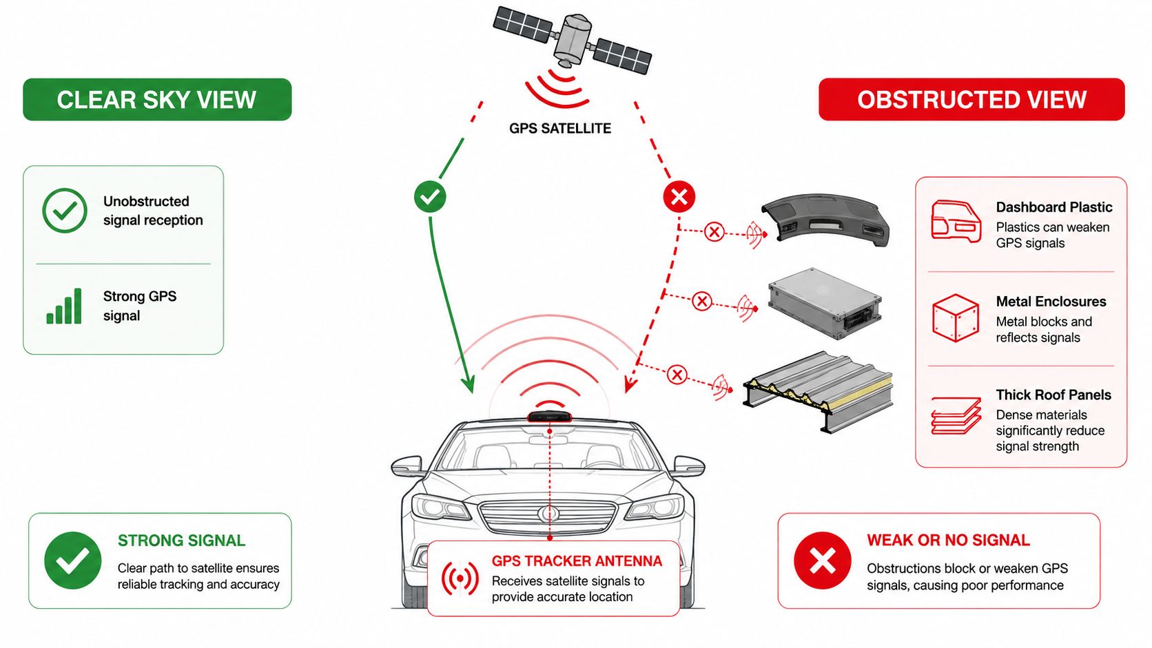
Under a dashboard, inside a metal enclosure, or beneath a thick roof panel, the receiver sees fewer usable satellites. A roof rack, roof box, metallic windshield film, or embedded heating layer can add more attenuation. Move the same device into open sky and the reported position may become stable without changing a single setting.
Buildings create false paths
Dense streets are difficult because satellite signals can bounce from glass, steel, and concrete. The receiver may combine a direct signal with a reflected one, or it may accept a reflected signal when the direct path is blocked. That is multipath and non-line-of-sight reception.
Multipath can create about 1 meter of position error in some cases, according to this GPS multipath reference. In a deep urban canyon, the result can be much worse. A 2025 urban-canyon model reduced horizontal RMSE from 13.0 meters to 4.7 meters and vertical RMSE from 19.5 meters to 6.9 meters using SNR-based weighting, as described in this FIG proceedings paper.
The map pin may jump to a parallel road, settle beside the vehicle's real route, or draw sharp corners that the car never made. Faulty-measurement exclusion helped reduce large errors to under 0.5% in one urban-canyon study, with mean lateral error below 1 meter in middle canyons. Deep canyons still produced errors above 10 meters, so filtering helps but can't defeat a blocked sky.
Test more than one difficult location
Parking garages can eliminate satellite reception. In that situation, the app may continue showing the last valid fix instead of the vehicle's current position. Trees and heavy precipitation can worsen a weak signal, but buildings and metal usually cause more serious trouble.
Test the tracker outdoors, near a window, in the usual parking location, and on a route with tall buildings. If the position improves outside, adjust the installation or reporting expectations before replacing the hardware. A vehicle locator such as CarLock's car locator can show the practical difference between a stable last fix and a live position, but no app can recover satellite measurements that the environment has blocked.
Use the following video as a visual explanation of how obstructions and reflections affect satellite positioning:
Beyond the Basics of Civilian GPS
A car can sit in the same driveway while its map pin drifts across the street. That does not automatically mean the tracker is defective. The receiver may be combining direct satellite signals with reflections, then reporting the best position it can calculate from measurements already damaged by the vehicle and its surroundings.
Metal dashboards, heated glass, underground garages, and tightly packed buildings can all contribute. Multipath begins when a signal bounces off a surface before reaching the antenna. Non-line-of-sight reception occurs when the direct route is blocked and the receiver follows a reflected path instead. The resulting coordinate can look plausible, so the fault seems random even when the same structure causes the same error repeatedly.
Multi-GNSS improves the measurement picture
A tracker supporting GPS, Galileo, GLONASS, BeiDou, or QZSS can draw from more than one satellite constellation. That may improve satellite geometry and reduce gaps when part of the sky is blocked. The improvement still depends on the receiver, antenna, signal quality, and local conditions. Adding constellations cannot recover signals that the car or a building has already blocked.
Satellite arrangement matters as much as satellite count. GDOP can exceed 10 when the geometry is poor, which can seriously weaken the position solution, according to this Institute of Navigation study. The study also identifies PDOP below 7 as generally required for 1-meter accuracy and PDOP below 3.5 as suitable for AutoTrac applications. Treat those thresholds as diagnostic clues, not promises for a concealed vehicle tracker.
Corrections belong to a different equipment class
A-GPS supplies orbital data so the device can acquire satellites faster. It does not turn a weak or reflected signal into a precise measurement. RTK and related differential methods use carrier-phase corrections and can produce centimetre-level results, but they require compatible receivers, antennas, correction data, and a sufficiently open sky view.
Under suitable conditions, RTK commonly provides centimetre-level horizontal accuracy. Vertical results are typically less accurate, often about 1.5 times worse, at the 95% confidence level. Ordinary security trackers generally lack the receiver, antenna, correction link, and processing required for that setup.
For a drifting vehicle pin, check installation, firmware, constellation settings, and cellular timeouts before considering specialist GNSS hardware or a correction service. Receiver-side changes can fix a bad installation. They cannot remove an environment-side limit caused by reflections or blocked sky.
A Quick Diagnostic Routine Before You Blame the Tracker
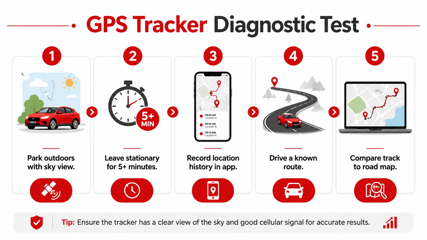
Run a controlled test instead of judging the device from one bad point. A short log gives an installer or manufacturer something useful to analyze.
Start with a stationary outdoor baseline
- Park outdoors: Choose a location with an unobstructed view of the sky, away from tall buildings and large metal structures.
- Wait several minutes: Leave the vehicle stationary so the tracker can acquire and settle rather than judging its first fix.
- Record the evidence: Note the displayed position, accuracy radius, satellite count if shown, cellular signal, update interval, and device status.
- Repeat the reading: Test the same location again after 10 to 15 minutes. A stable pin or small scatter tells you more than one isolated report.
- Drive a known route: Include open road, trees, tall buildings, and an overpass. Save every visible jump and compare the track with the actual road.
At home, compare the normal parked reading with the tracker placed near a window and then outside the vehicle, if the installation allows a safe test. A strong improvement outside points toward antenna placement or vehicle materials rather than a failed chipset.
Check configuration before cycling power
Verify location permissions, high-accuracy mode, roaming, mobile data, firmware, and the tracker's time and configuration. Check whether the app has delayed data while the tracker itself is operating correctly. Save screenshots and logs before restarting or power-cycling the unit.
Bring useful evidence: A device model, firmware version, signal readings, test locations, route logs, and installation photographs are far more valuable than “the GPS is drunk.”
If open-sky accuracy remains outside the tracker's stated specification, move the antenna and repeat the test. When the problem continues, send the manufacturer the complete test record through its tracker questions and support guidance. That lets support separate a reception problem from a hardware or service fault.
Putting It All Together
GPS accuracy behaves more like tire wear than a one-time repair. You monitor it, identify patterns, and correct the highest-impact cause first. Chasing a new setting while the antenna is buried behind metal is the positioning equivalent of balancing a tire with a damaged wheel.
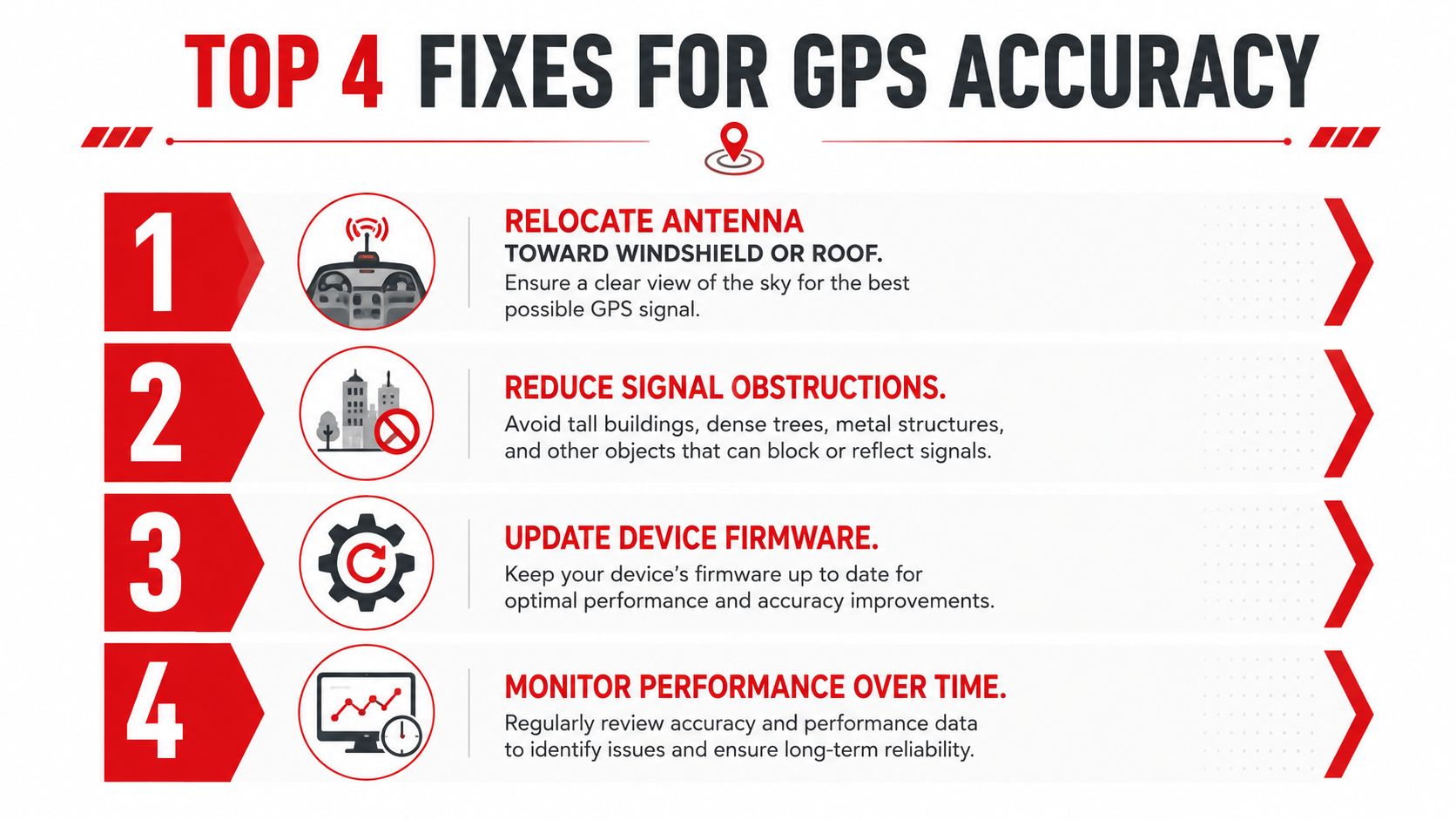
Use this priority order:
- Relocate the antenna: Move it toward a windshield or roof-panel line of sight while keeping the tracker difficult to tamper with.
- Reduce obstructions: Avoid the engine bay, A-pillar structure, rear parcel shelf, metal boxes, and heavily shielded dashboard locations.
- Update the receiver: Install current firmware and enable multi-GNSS and A-GPS when supported.
- Audit recurring locations: Mark garages, alleys, urban canyons, and other places where the route repeatedly scatters.
Make the check part of maintenance
Once a month, pull a short accuracy log from the app. Review the satellite count and HDOP values when available, compare parked positions with known locations, and note whether errors happen only in one neighborhood or under one parking structure. Reset the device after unusually long parked periods only after preserving the diagnostic record, because a restart can remove clues about what happened.
A standard GPS environment can still vary substantially. One classic reference described expected horizontal accuracy of 100 meters or better about 95% of the time under specified conditions involving a 24-satellite constellation, a 5-degree elevation mask, no obstructions, at least four satellites in view, and PDOP of six or lower, as documented in this GPS World reference. Vehicle owners should read that as a reminder that conditions matter, not as a promise that every modern tracker will behave the same way everywhere.
The practical lesson is simple. Move the antenna before replacing the device, test open sky before blaming the software, and log patterns instead of reacting to one wandering pin. Civilian GPS rewards consistent maintenance, realistic expectations, and an installation that gives the receiver a fair view of the sky.
CARLOCK combines real-time GPS tracking with cellular connectivity, route history, movement and tamper alerts, engine-start notifications, and battery monitoring for vehicle security. If you want to test your installation, monitor recurring drift, and receive timely information when your car moves unexpectedly, visit CARLOCK and review the tracker options.