

Driver’s Desk
Best GPS for Police Officers: Fleet Tracking Guide
The number that best reframes the best GPS for police officers debate is not a receiver specification. It's the expansion of electronic monitoring from about 53,000 accused and convicted people in 2005 to more than 125,000 in 2015, an increase of roughly 140%, according to Pew's review of electronic offender tracking. In the same survey, manufacturers reported about 88,000 GPS units in offender supervision, compared with roughly 2,900 a decade earlier, a thirtyfold increase.
That history matters for police fleets because it shows how location technology became an operational system, not a novelty. The right product now has to do more than place a vehicle on a map. It must support dispatch, officer safety, evidence review, urban positioning, vehicle recovery, labor agreements, and controlled access to sensitive movement data.
The comparison below is a practical buying lens. It separates verified capabilities from specifications that require vendor validation, because public-safety procurement shouldn't treat an attractive dashboard as proof of dependable field performance.
| Evaluation area | What a police fleet should require | Why it matters |
|---|---|---|
| Location visibility | Near-real-time updates, historical routes, and event alerts | Dispatchers need current unit status and supervisors need an auditable record |
| Position quality | Multipath mitigation, high-sensitivity reception, and continuity tools | Tall buildings, garages, tunnels, and obstructed streets can distort fixes |
| Vehicle resilience | Hardwired installation, tamper detection, and durable components | Pursuits, collisions, maintenance, and evidence handling expose weak hardware |
| Integration | AVL, CAD, GIS, reporting, and role-based access | A tracker becomes useful when location data reaches the right workflow |
| Governance | Retention rules, duty-state controls, and documented access | Safety monitoring can become contested employee surveillance without limits |
The Evolution of GPS in Law Enforcement
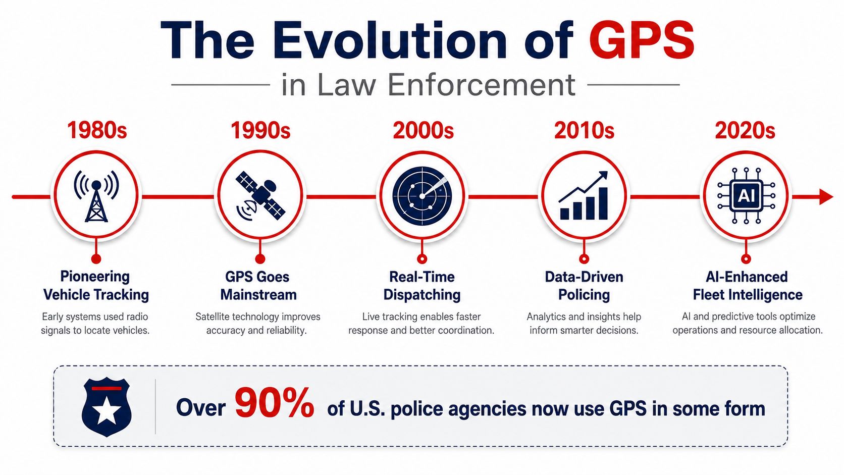
GPS became a law-enforcement supervision tool when agencies moved from occasional location checks to continuous visibility. In January 1997, the Florida Department of Corrections began a pilot using GPS to track offenders in real time, 24 hours a day, with probation officers notified as violations occurred, as documented in the Office of Justice Programs record on real-time offender tracking. That milestone shows the essential transition. GPS stopped being only a navigation aid and became a live operational layer for public safety.
By the late 1990s and early 2000s, police agencies were increasingly using GPS devices to monitor suspects and gather evidence. The 2015 monitoring figures cited above show the consequence of that shift. GPS-supported oversight moved into routine supervision and compliance operations because agencies could see location activity as events unfolded, rather than reconstructing movement only after an incident.
From vehicle visibility to dispatch infrastructure
Automatic Vehicle Location, or AVL, extended that logic into patrol operations. Public-safety agencies use AVL and GPS to identify emergency-response vehicles and dispatch the closest appropriate unit. The Arizona State University Center for Problem-Oriented Policing reference on AVL describes systems that can operate within seconds and connect GPS with GIS to reduce dispatch time and error.
The Office of Justice Programs overview of AVL in front-line policing adds a safety-critical use case. Dispatchers can trace an officer's vehicle if the officer is incapacitated and unable to communicate, while also identifying nearby units for emergency deployment. That makes GPS less like a passive tracker and more like a second communication channel when radio contact fails.
Operational conclusion: The best system isn't the one with the most map features. It's the one that turns a location fix into an immediate, defensible action.
Modern AVL also supports route history, incident reconstruction, fleet utilization, and less radio traffic during dispatch. A government study of automatic vehicle location in law enforcement notes that AVL can document the sequence of events, reduce reliance on voice radio, and help agencies use larger fleets more efficiently. The technology therefore sits beneath CAD, GIS, supervision, and accountability, provided the department defines who can access the data and why.
For agencies assessing police vehicle tracking capabilities, the historical lesson is straightforward. GPS adoption accelerated because leaders needed live operational awareness, but the same visibility creates obligations around accuracy, retention, access, and employee trust.
Core Requirements for Police Fleet Tracking
A police tracker should be evaluated as field infrastructure, not as a consumer gadget with a law-enforcement label. Start with the physical environment. Exterior antennas and vehicle-mounted devices face vibration, impact, weather, wiring work, and tampering, so agencies should ask vendors to document ruggedization rather than accept general language such as “built for fleets.”
Hardware that can survive the assignment
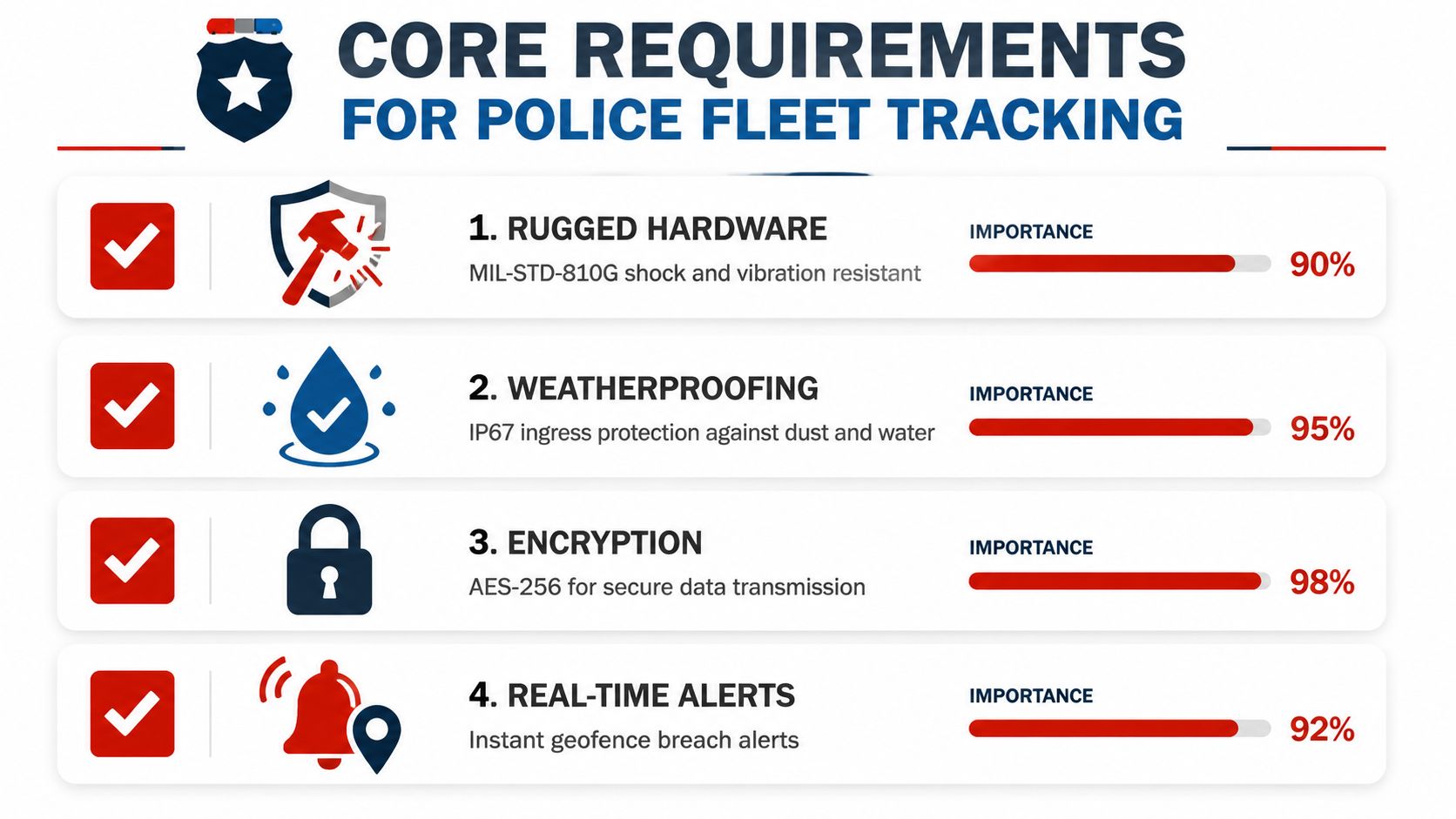
The procurement checklist should include MIL-STD-810G shock and vibration resistance, IP67 ingress protection for exposed components, and an operating range from -40 °C to 85 °C where the installation requires it. These specifications describe resistance and environmental tolerance, but they don't automatically prove reliable positioning. Agencies still need installation testing on the actual patrol vehicle, including light bars, partitions, roof equipment, and electrical accessories.
A dual-constellation GNSS receiver, such as GPS combined with GLONASS or Galileo, can give the receiver more signals to evaluate. Dead-reckoning sensors, using inertial measurements, can help maintain an estimated path through tunnels and parking structures when satellite visibility disappears. Cellular assistance can shorten acquisition, while a satellite fallback path may matter for remote operations, but both need validation against the agency's coverage map and mission profile.
Security belongs in the hardware decision, too. Location data can reveal patrol patterns, officer movements, investigative activity, and emergency deployments. Agencies should require AES-256 encryption for data protection and ask whether cryptographic modules have FIPS 140-2 validation, rather than treating a vendor's generic “encrypted” claim as sufficient.
Software that produces an accountable record
The platform should support short update intervals, geofence-triggered alerts, tamper logs, historical route playback, and a cloud environment that meets the agency's CJIS requirements. A public-safety telematics platform describes updates as frequent as every five seconds, with views showing the closest unit, en-route status, on-scene status, patrol gaps, route playback, and event-based geofencing in its AVL product documentation. That is a useful reference point, but buyers should test the actual configured interval under cellular congestion instead of relying on a brochure setting.
Tamper detection deserves special attention. A disconnected device, altered wiring harness, or sudden loss of reporting can be a safety event, an equipment issue, or an attempt to defeat oversight. The system should record the event, notify authorized personnel, and preserve a clear audit trail.
Commercial fleet trackers often prioritize dispatch visibility, maintenance, and driver behavior. Those functions can be valuable, but police deployments add higher consequences. A device that misses a location during a pursuit, loses a route history needed for an investigation, or exposes live officer positions to too many users creates a different category of risk. Vehicle-health data can complement location monitoring through vehicle health tracking tools, but agencies should keep operational, evidentiary, and employee-monitoring requirements distinct during procurement.
Comparing Top AVL and Telematics Platforms
A useful comparison separates verified capabilities from procurement assumptions. Public material reviewed here does not establish a common ping rate, CJIS hosting status, five-year price, or ruggedization score for Motorola Solutions CommandCentral, Geotab GO9, Samsara VG55, or Panasonic Toughbook-integrated OEM modules. The distinctions below are therefore operational starting points, not equivalent product scores.
| Platform | Confirmed or defining capability | Main validation risk |
|---|---|---|
| Motorola Solutions CommandCentral | Public-safety command platform designed to connect dispatch and operational workflows, with integration advantages for agencies already using Motorola systems | Confirm CAD, RMS, external GIS, regional mutual-aid exchange, hosting scope, and export controls |
| Geotab GO9 | Open telematics hardware and software model that can expose vehicle data through an SDK for custom reporting and system connections | Test CAD, RMS, GIS, identity controls, retention rules, and cellular behavior in the agency's configuration |
| Samsara VG55 | Vehicle gateway positioned for location, camera, event review, and driver-behavior workflows in one operating environment | Verify timestamp alignment, event triggers, permissions, video export, and incident-file integrity |
| Panasonic Toughbook-integrated OEM modules | Rugged in-vehicle computing with vehicle-specific integration options for mobile command, tactical, and demanding installations | The computer's durability does not establish GNSS accuracy. Test receiver, antenna, cellular modem, module, and vehicle together |
What the platforms represent
Motorola Solutions CommandCentral is primarily a public-safety ecosystem choice. Its value may be highest where dispatch, records, communications, and command workflows already use compatible Motorola systems. That advantage can reduce interface work, while increasing dependence on the vendor's integration boundaries. Agencies requiring external GIS, mutual-aid data exchange, or portable exports should test those paths before contracting.
Geotab GO9 represents the open telematics approach. An SDK can support connections to existing systems, specialized reports, and broader fleet operations. It also shifts more responsibility to the agency or its integrator. Open access does not ensure that CAD, RMS, GIS, user permissions, and retention policies will function together without configuration and ongoing support.
Samsara VG55 suits departments evaluating vehicle location alongside cameras and event review. The meaningful test is the complete evidence workflow. Location, video, trigger data, user permissions, timestamps, and exported files should remain consistent during an incident review, including periods of weak cellular service.
Panasonic Toughbook-integrated OEM modules emphasize durable computing and purpose-built vehicle installation. That can fit mobile command units, tactical vehicles, and patrol cars exposed to vibration or difficult mounting conditions. GNSS performance still depends on receiver design, antenna placement, sky visibility, cellular conditions, and the selected software interface.
Urban streets expose a difference that a live map can conceal. Reflections between tall buildings can create multipath errors, while garages and tunnels produce gaps or delayed points. Require every finalist to run the same callout through dense streets, a garage, a tunnel, and a rural dead zone. Compare exported tracks, timestamps, outage records, and recovery behavior, not only the screen shown during the test.
Foot patrol introduces a separate design question. A vehicle AVL platform can show the assigned car while providing little visibility into an officer who leaves it. Agencies should decide whether the requirement is vehicle dispatch, personnel safety, or both, then assess device burden, battery handling, activation rules, and privacy controls rather than treating a vehicle gateway as a universal solution. Features described in mobile fleet tracking and app features can inform the mobile-app side of that evaluation, but they do not replace an agency test.
A department with fewer than 50 vehicles typically benefits more from a single-platform solution with basic geofencing than from an enterprise suite that requires dedicated IT staffing. Larger agencies should prioritize CAD and RMS integration, identity management, evidence export, outage handling, and documented hosting and retention controls.
The five-year total cost requires separate line items for hardware, cellular service, software licensing, installation, replacement units, integration, training, support, and data retention. Without those components, a five-year, 200-vehicle total is a sales estimate rather than a comparable fact.
Navigating Privacy and Labor Union Concerns
Constant location monitoring creates a governance problem, not only a technical one. Command staff may need to identify the nearest unit, confirm whether a vehicle moved after a serious event, or reconstruct a collision. Officers and unions may object when the same records support routine discipline, off-duty surveillance, or minute-by-minute performance pressure.
Coverage of GPS in police vehicles and officer surveillance shows why procurement must address more than positional accuracy. A department should document who sees live location, when tracking operates, how long records remain available, and which uses are prohibited. It should also publish a clear police GPS privacy policy explaining what the system collects, who may access it, and how officers can challenge misuse.
Build the policy before installing the hardware
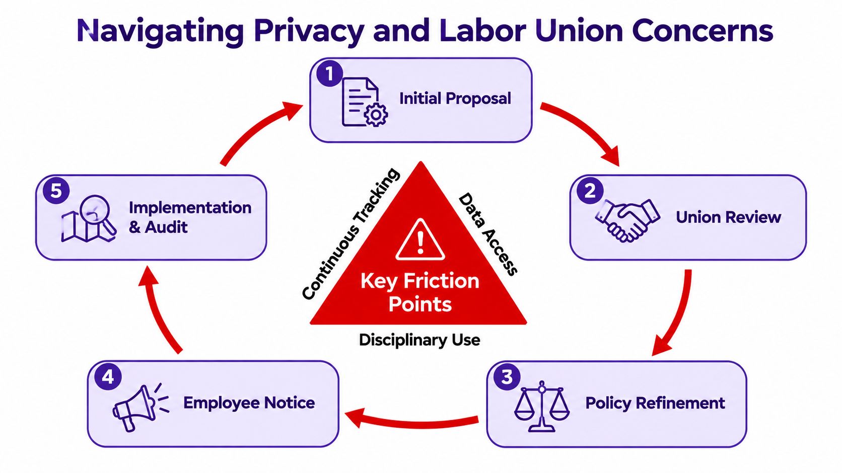
A defensible deployment brings command staff, legal counsel, labor representatives, records management, information security, and frontline officers into the design review. The policy should separate live emergency access from historical administrative access. It should define duty status, vehicle assignment, investigative exceptions, logged emergency overrides, and the conditions under which location records may enter an internal-affairs process.
A law-enforcement governance model should include:
- Role-based access: Dispatchers receive the live view needed for deployment. Supervisors, records staff, and investigators receive narrower permissions tied to their duties.
- Duty-state controls: Tracking rules should follow on-duty and authorized operational status. Any emergency override needs a reason code and audit record.
- Retention limits: Keep location records for the period required by the applicable evidence-retention schedule. Auto-delete passive patrol-location data after the agency's approved period unless it is tagged to an incident or investigation.
- Audit trails: Record who viewed, exported, changed, or shared a location record, including the purpose and authorization.
- Clear notice: Officers should know whether speed, route, idle time, or location data can affect discipline, investigations, or performance reviews.
Collective bargaining can turn these controls into enforceable operating rules. For example, a department may agree to provide advance notice before activating continuous location tracking and require an independent audit when location data is used in disciplinary proceedings. That arrangement gives labor representatives a review mechanism without blocking emergency use.
The policy must protect dispatch access while preventing unrestricted browsing of historical movements. A pilot with written officer feedback can expose duty-status errors, shift-change problems, and alerts that create pressure around low-value exceptions. Privacy therefore belongs in system design, labor negotiations, access configuration, and records procedures before hardware reaches patrol vehicles.
Overcoming Urban Canyon Signal Challenges
Tall buildings create a positioning problem that ordinary buyer guides often hide. Reflected signals can make a receiver believe a satellite signal traveled along a path it didn't take, while blocked line of sight removes useful measurements altogether. In severe urban-canyon conditions, pseudorange errors can reach about 20 meters, and non-line-of-sight errors can become effectively unbounded, with practical multipath excursions reaching 100 meters, according to NATO research on GNSS performance in urban canyons.
Those errors are operationally meaningful. A dispatcher may see a patrol vehicle on the wrong side of a divided street, a supervisor may misread the route after an incident, and a recovery team may search the wrong access road. The solution isn't merely to demand “more accurate GPS.” It's to combine receiver quality, antenna design, inertial continuity, and software filtering.
The receiver and antenna make the difference
Deep GNSS and inertial-navigation integration has demonstrated continuous carrier-phase tracking in dense urban-canyon testing, with centimeter-per-second velocity accuracy. In the same environment, commercial low-sensitivity GPS receivers showed velocity errors of around 1 m/s. The study also reported usable tracking from 5 to 6 satellites when buildings obstructed line of sight, and tracking remained possible at carrier-to-noise ratios as low as 12 dB-Hz, as reported by the Institute of Navigation's urban-canyon study.
Improved weighting and multipath models can materially reduce error. One urban-canyon study reduced horizontal RMSE from 13.0 meters to 4.7 meters and vertical RMSE from 19.5 meters to 6.9 meters, with three-dimensional accuracy improving by up to 22.4 meters, according to the NATO reference above.
| Receiver chipset | Constellations supported | Urban accuracy (m) | Cold-start TTFF (s) | Dead-reckoning support | Power draw (mW) |
|---|---|---|---|---|---|
| u-blox | Confirm exact module and enabled constellations | Require agency test data | Require cold-start test | Confirm module and sensor integration | Obtain datasheet value |
| Qualcomm | Confirm exact platform and enabled constellations | Require agency test data | Require cold-start test | Confirm platform support | Obtain datasheet value |
| Broadcom | Confirm exact module and enabled constellations | Require agency test data | Require cold-start test | Confirm platform support | Obtain datasheet value |
The table is intentionally a validation matrix, not a fabricated ranking. Chipset family alone doesn't establish field accuracy. Antenna placement, vehicle roof exposure, cable quality, firmware, sensor calibration, cellular assistance, and filtering all influence the result.
For dense-city patrol, test roof-mounted and concealed installations separately. Light bars, roof equipment, metal cages, and dashboard structures can attenuate or distort reception. A unit that performs well on an open-road demonstration may behave differently during a foot-patrol transition, inside a garage, or between high-rise facades. Device-level details such as installation options and supported features should be checked against the tracker hardware documentation, then verified in the department's own streets.
Strategic Recommendations for Agency Deployment
GPS procurement should follow the mission, not the size of the vendor's feature list. A small rural sheriff's office, a mid-size municipal department, and a large metropolitan agency face different coverage, staffing, integration, and governance constraints. The same device can be sensible for a marked vehicle and unsuitable for a foot patrol, K-9 team, SWAT element, or unmarked investigative car.
Match the system to the operating profile
| Agency profile | Recommended starting point | Priority capabilities | Main caution |
|---|---|---|---|
| Small rural agency | Simple hardwired or plug-in vehicle tracker with a clear dashboard | Location visibility, basic geofencing, tamper alerts, low IT burden | Confirm rural coverage and offline behavior |
| Mid-size department | Rugged AVL unit integrated with CAD, GIS, and reporting | Reliable update behavior, role-based access, route history, incident exports | Don't buy integration promises without a live test |
| Large metropolitan department | Enterprise public-safety telematics platform | Fleet scale, mutual-aid interoperability, analytics, security, governance | Complexity can expand cost and administrative exposure |
| Specialized units | Mission-specific vehicle or personnel device | Form factor, battery, concealment, indoor continuity, alert logic | Vehicle tracking alone may not cover foot operations |
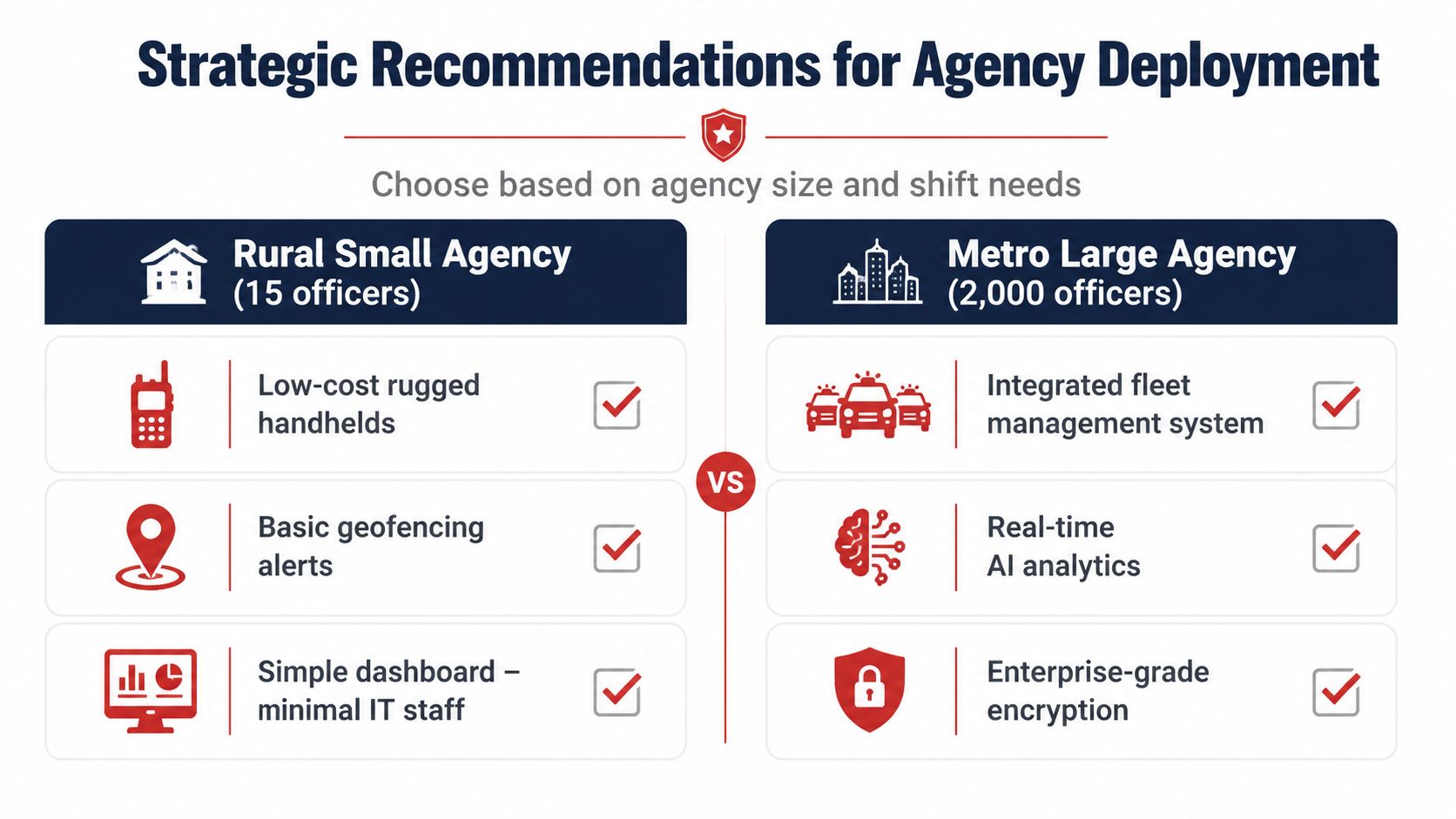
For a rural agency, simplicity can be a safety feature. A cloud dashboard, basic geofencing, and dependable tamper alerts may deliver more value than a complex analytics suite that nobody has time to administer. Mid-size departments should prioritize hardwired AVL, CAD integration, encrypted data paths, and policies that separate dispatch visibility from employee surveillance.
Large metro departments need a different architecture. They should test thousands of assets, multiple shifts, regional mutual-aid access, emergency overrides, data export, and outage recovery. Predictive analytics can support fleet decisions, but it shouldn't displace receiver testing or policy work. An advanced model cannot correct a multipath error caused by a poor antenna installation.
Procurement teams should phase the rollout. Begin with high-risk patrol zones and the vehicle types most connected to emergency response. Measure dispatch usability, location continuity, alert quality, export integrity, and officer feedback before expanding. For agencies navigating public-sector purchasing, Software for Government contracting can help teams understand the broader contracting environment, but the technical evaluation still has to come from controlled field trials and documented requirements.
The buying verdict is conditional. Best overall means the platform with the strongest CAD integration, security controls, field-tested positioning, and workable labor policy for that agency. Best value is the system that meets the mission without paying for unused complexity. Best for specialized units is usually not the same platform as best for patrol vehicles, because foot operations require different battery, form-factor, indoor, and alert decisions.
A vehicle-focused option such as CARLOCK can provide real-time GPS location, trip history, mobile visibility, and alerts for movement, engine starts, vibration, disconnection, and battery conditions. It may fit private, recovery, or limited fleet-monitoring scenarios, but agencies should verify CJIS, labor, evidence, integration, and public-sector procurement requirements before treating any consumer-oriented vehicle security product as a full AVL replacement.
CARLOCK provides real-time vehicle location, trip history, mobile monitoring, and activity alerts that can support vehicle security and recovery workflows, while agencies should match those functions against their public-safety policies and integration needs. Review the available capabilities and determine whether they fit your vehicle-monitoring use case by visiting CARLOCK.