

Driver’s Desk
How Accurate Is a GPS System
Under open sky, consumer GPS is typically accurate to roughly 4.9 meters, while the FAA reports about 7.0 meters 95% of the time, but real driving conditions stretch that into a much wider range. A vehicle can sit within a few meters of its true position on an open road, then appear tens of meters away when buildings reflect or block the satellite signals.
That difference explains why the question “how accurate is a GPS system?” doesn't have one universal answer. GPS accuracy is a moving target shaped by the sky above the vehicle, the surrounding buildings, the receiver and antenna, cellular availability, and the way the tracker processes each position update.
For a car owner, the practical question isn't whether a tracker can identify the exact lane at every moment. It's whether the system can reliably show which road, driveway, parking lot, or neighborhood contains the vehicle, and whether it keeps communicating when conditions become difficult.
What GPS Accuracy Actually Means
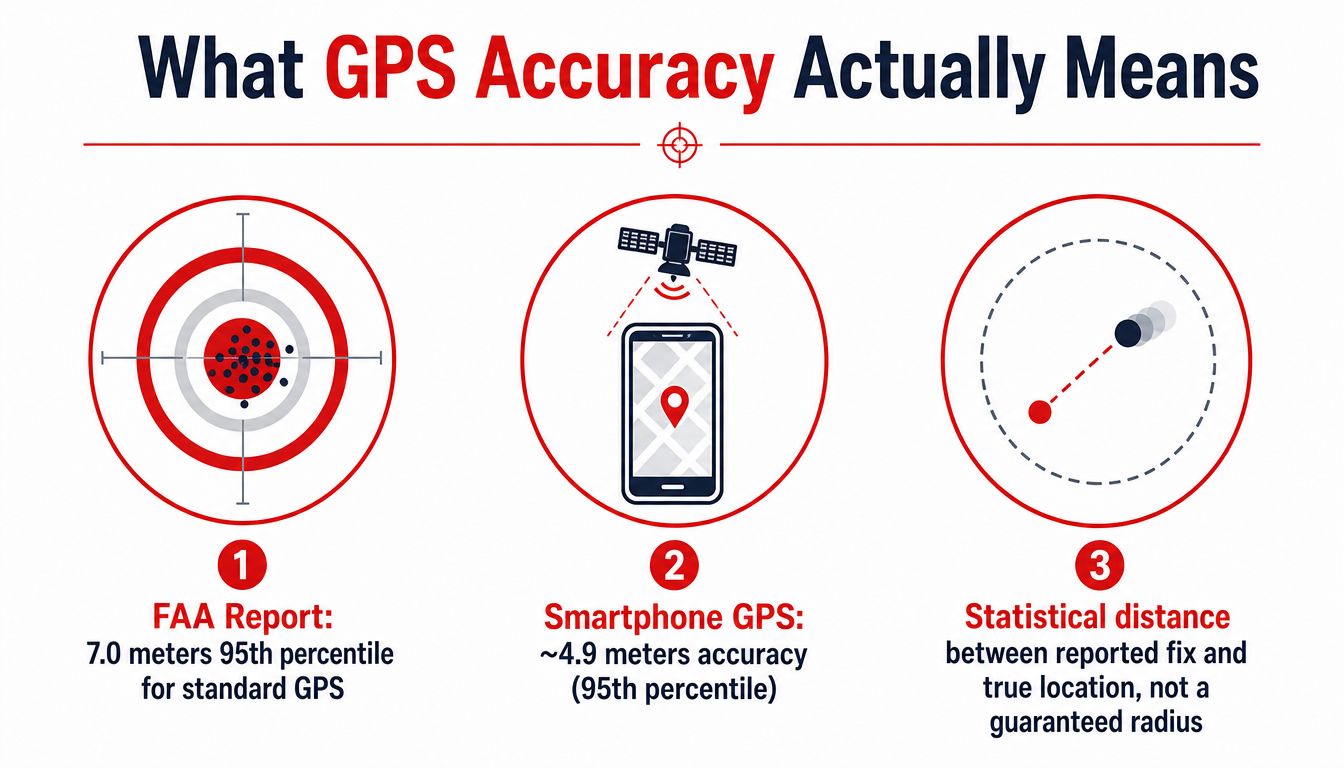
The FAA reports about 7.0 meters of accuracy 95% of the time for the basic GPS service, while official guidance says GPS-enabled smartphones are typically accurate within a 4.9-meter radius under open sky (GPS.gov guidance on GPS accuracy). Those figures describe statistical performance, not a permanent circle that guarantees every location fix will land inside its boundary.
A useful mental model is a dartboard. Most reported positions cluster near the vehicle's true location, but some land farther away. The 95% figure means the stated threshold contains most results under the defined conditions. It doesn't mean every fix will be equally close, and it doesn't describe performance inside a garage, beside tall buildings, or under heavy tree cover.
Accuracy and precision are different
Accuracy describes how close a reported position is to the truth. Precision describes how tightly repeated readings gather together. A tracker might repeatedly report a position a short distance from the car, which makes it precise but not fully accurate. Another device might produce readings that vary around the true position, giving a better average but a less stable visual trail.
Manufacturers and engineers also describe positioning performance through different statistical conventions. CEP generally describes a circular area containing a defined portion of fixes, R95 describes a radius containing 95% of fixes, and 2DRMS uses a different statistical distance convention. Two trackers can therefore appear to have very different specifications even when their real-world behavior is more similar. You need to know the reporting method before comparing figures.
The satellite signal isn't the whole result
The GPS system's signal-in-space performance is measured separately from the accuracy a driver sees on a map. Official GPS performance information reports a 95% horizontal error of 8 meters or less as a global average and 15 meters or less at the worst site, while vertical error is 13 meters or less globally and 33 meters or less at the worst site (GPS.gov GPS performance data).
Those system-level figures don't account for every vehicle's antenna position, reflections, atmospheric conditions, or surrounding obstructions. A hardwired vehicle tracker, such as a device described through CarLock's GPS car tracker features, should therefore be judged by how it behaves across the environments where the car travels, not by one ideal-sky number.
Where GPS Accuracy Comes From and Where It Breaks
A GPS receiver estimates distance by timing how long signals take to travel from satellites. Think of each satellite as holding one end of an invisible tape measure. If the timing is slightly wrong, the measured distance is wrong, and the calculated vehicle position shifts.
The receiver also depends on accurate timing. A small clock error at the satellite or inside the receiver behaves like a clock that runs slightly fast or slow. The position calculation must separate that timing error from the vehicle's location, so imperfect synchronization adds uncertainty.
Four contributors to the final fix
Atmospheric delay creates another distortion. The ionosphere and troposphere slow signals as they pass through the atmosphere, much like a mirage makes a distant object appear displaced. Modern systems model these effects, but the correction isn't perfect.
Satellite geometry matters because the receiver needs satellites spread across the sky, not clustered in one direction. When the visible satellites form a poor shape, even a modest ranging error can produce a larger position error. Buildings, bridges, trees, tunnels, and reflective surfaces then remove or distort the signals the receiver needs.
| Error source | Typical range (m) | Behavior |
|---|---|---|
| Satellite geometry | Environment-dependent | Poor geometry amplifies other errors rather than creating one fixed offset |
| Atmospheric delay | Variable | Ionospheric and tropospheric effects alter signal travel time |
| Multipath and NLOS reception | Can reach tens of meters in urban canyons | Reflected or indirect signals create biased distance measurements |
| Receiver and antenna quality | Variable | Sensitivity, installation, firmware, and filtering affect the final fix |
The ranges above shouldn't be added as if they were fixed allowances. Error sources interact, and a good satellite layout can reduce the effect of one problem while a blocked antenna can make another much worse. A University of Calgary GNSS study identifies multipath as a major source of error in urban canyons, where signals often arrive through reflection and diffraction rather than direct line of sight (University of Calgary urban GNSS research).
A hardwired tracker helps operationally because it has consistent vehicle power and can be installed where its antenna has a reasonable view of the sky. Longer observation time, receiver filtering, and cellular communication can also make the reported history more useful, even though they can't repeal the physical limits imposed by a concrete structure or a metal roof.
Practical rule: Treat a GPS specification as a starting condition. The antenna's location and the environment around the vehicle often matter more than the headline number.
Why City Driving Breaks the Numbers
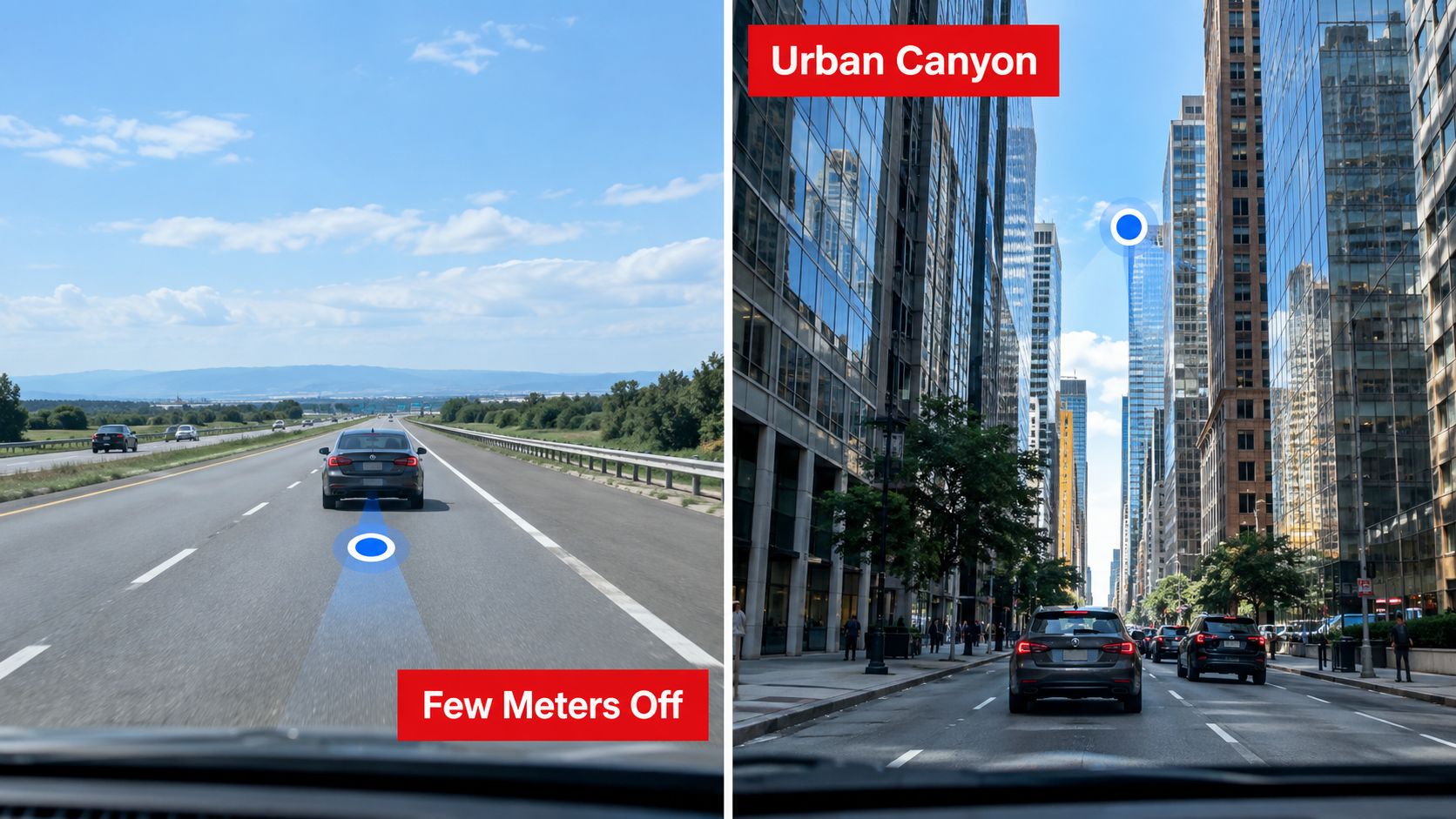
On an open highway, a vehicle usually has a broad view of the sky. The receiver can work with direct satellite signals, and the map position may stay within a few meters of the road. As the car enters a downtown corridor, the same receiver faces a very different problem.
Glass towers reflect signals. Concrete buildings block satellites on one side of the street. The receiver may still report a position because it can hear enough signals to calculate one, but some of those signals have bounced off walls or arrived from an indirect path. The resulting fix can shift toward a parallel street, a building entrance, or the visible side of the road.
What multipath looks like from the driver's seat
Suppose the car turns between tall buildings and the map marker begins drifting. The tracker isn't necessarily malfunctioning. A reflected signal can make the receiver believe a satellite is farther away than it really is, while a non-line-of-sight signal can introduce an uneven delay from one direction. The position solution then moves even though the vehicle is traveling normally.
Research on dense urban conditions has reported chip-level outputs ranging from 5 meters to 58 meters, and another study reported horizontal RMSE improving from 13.0 meters to 4.7 meters after mitigation (EGU 2025 urban GNSS study). A separate urban-canyon result found mean horizontal error improving from roughly 18 meters to about 2 meters after multipath mitigation (urban GNSS mitigation research).
These results show why light urban streets and dense downtown cores shouldn't be assigned one universal accuracy value. In a lightly built area, a position may remain close enough to identify the road. In a dense canyon, the marker can move by tens of meters or more, especially when the vehicle stops beside reflective buildings.
A CarLock car locator is most valuable in the same environments where this uncertainty needs careful interpretation. If a stolen vehicle moves through a city, the map history should be read as a sequence of location estimates, alerts, and travel direction, not as proof of the exact lane at every timestamp.
The video below provides a visual explanation of how satellite positioning behaves in real environments.
Bluetooth vs Cellular vs GPS Trackers
Vehicle trackers use different ways to estimate location, and the word “tracker” doesn't guarantee the same performance. Bluetooth tags, cellular-only devices, and GPS-based systems solve different problems.
A Bluetooth tag depends on a paired phone or nearby participating devices. It can help locate an item when a compatible phone comes close, but the tag doesn't independently calculate and transmit a vehicle's position. That makes it useful for keys or bags, not a complete vehicle-security system.
Cellular-only trackers estimate position from nearby network towers. This works when satellites are blocked, including some indoor or shielded locations, but the result is generally coarse. Tower-based positioning can identify a broad area without placing the car confidently on a particular street.
GPS-based trackers receive satellite signals and calculate latitude and longitude. Under open sky, consumer positioning is commonly measured in the few-meter range, while buildings, trees, bridges, and reflections can make the result substantially worse (GPS.gov explanation of environmental accuracy).
| Tracker type | Typical accuracy | Range | Best use case |
|---|---|---|---|
| Bluetooth tag | Nearby-device dependent | Short local proximity | Finding personal items |
| Cellular-only tracker | Coarse tower-based location | Cellular network coverage | Broad-area reporting when satellite signals are blocked |
| GPS-based tracker | Few meters under open sky, worse in obstructions | Satellite plus communication coverage | Vehicle location, route history, and movement alerts |
Why update behavior matters
A GPS receiver can calculate a position more often than a service chooses to display it. Trackers commonly adjust updates around motion, ignition, alerts, or configured schedules. That approach balances useful information with power consumption and network traffic, but it means a map shouldn't be interpreted as a continuous video feed.
Remote roads create another trade-off. GPS can calculate a good position where the sky is open, but a device still needs a communication path to send that position to your phone. A hybrid tracker combines satellite positioning with cellular reporting, and some systems can use other signals when satellite reception becomes unreliable.
If you're comparing a vehicle security device with a Bluetooth product, review the manufacturer's explanation of its CarLock GPS tracker tag features. The important distinction is whether the product was built to monitor a vehicle independently or to help a nearby phone find a misplaced object.
How Assisted GPS and Cellular Keep Tracking Alive
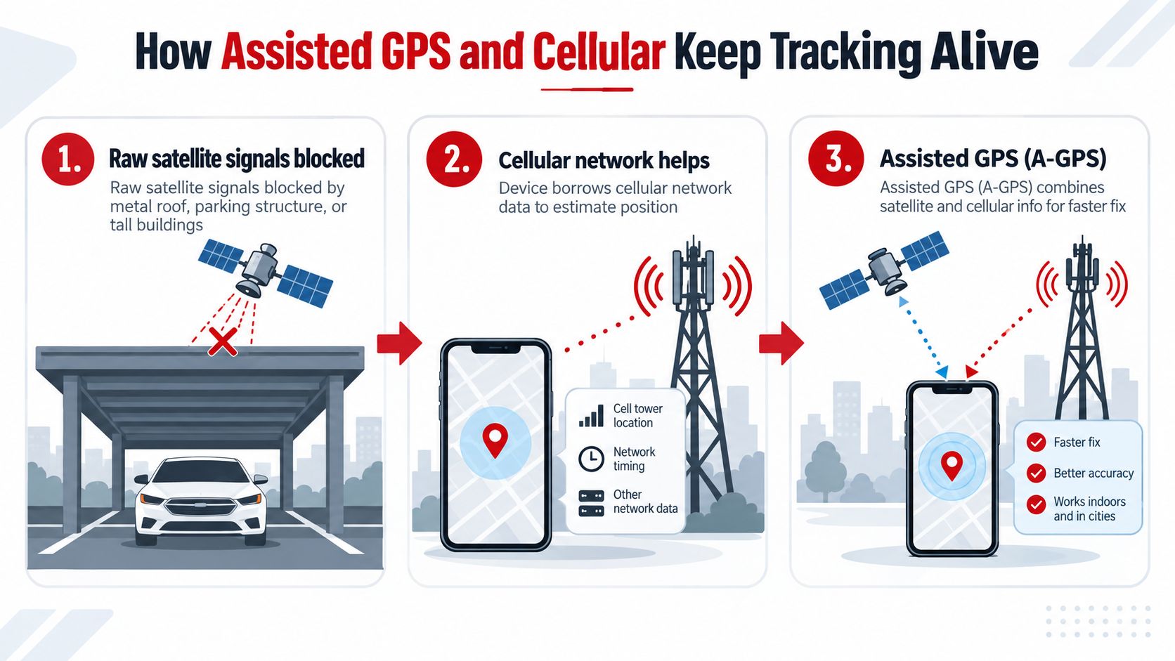
Raw satellite positioning becomes fragile under a metal roof, inside a parking structure, or between tall buildings. A receiver may hear too few clean signals to calculate a dependable fix, so modern location systems use outside information to shorten the search and preserve reporting.
Assisted GPS, or A-GPS, supplies approximate satellite orbit information and a coarse time reference through a cellular or Wi-Fi connection. The receiver starts with a better idea of where to look and what time it is, rather than beginning from a completely cold state. The result is a faster first fix, especially after the vehicle has been stationary or the device has lost satellite visibility.
The layers behind a usable track
Cellular positioning adds a second, less precise location source. Tower information may only narrow the vehicle to a general area, but it can keep the device communicating when the satellite view is masked. That distinction matters because a rough location with a recent timestamp may be more useful than a highly accurate fix that never reaches the owner.
Other supporting layers include:
- Cloud buffering: The device can preserve the last valid position and upload it when communication returns.
- Motion sensing: Accelerometers can help identify movement during short periods when satellite fixes are unavailable.
- Dead reckoning: Speed and direction estimates can bridge a brief tunnel or covered section, although drift grows without a fresh position reference.
- Wi-Fi fingerprinting: Recognized network environments can help estimate location inside some buildings or garages.
- Antenna placement: A clear installation location gives the receiver a better chance of hearing direct signals.
- Server-side filtering: Software can reject implausible jumps and present a smoother travel history.
These layers don't turn an underground garage into an open field. They make the overall system more resilient by separating position calculation from position delivery. A tracker may know the last reliable outdoor location, detect that the vehicle moved, and reconnect when it emerges.
For fleet managers, the same principle appears in discussions of field team visibility with GPS, where the operational value comes from maintaining usable awareness across a journey rather than demanding perfect coordinates at every instant.
A device's cloud and reporting behavior can be as important as its receiver, which is why CarLock cloud tracking features deserve attention alongside the advertised GPS accuracy.
A dependable tracking system doesn't need perfect reception every second. It needs to identify uncertainty, preserve useful history, and recover cleanly when the signal returns.
When Accuracy Stops Being the Main Problem
A pinpoint coordinate has no value if the tracker can't report it. Availability, integrity, and continuity can matter as much as the distance between a reported fix and the true location.
Jamming overwhelms weak satellite signals and can prevent a receiver from forming a position at all. Spoofing is more deceptive. Instead of silencing the receiver, a spoofer can broadcast false signals that persuade the device it occupies another location. The map may show a smooth but false journey, which is more dangerous than an obvious gap.
The difference between wrong and missing
A vehicle inside a shipping container, beneath a reinforced parking deck, or in a heavily obstructed city corridor may hear too few usable satellites. At that point, the error isn't a larger circle. The device may have no trustworthy satellite solution, may rely on a coarse alternative, or may stop reporting until it regains connectivity.
Urban multipath can also shift a position by tens of meters, according to research on non-line-of-sight signals and mitigation methods (University of Calgary study of urban-canyon errors). That can place a vehicle on the wrong side of a divided highway or on a nearby parallel road at the moment an owner needs to interpret the map.
Intentional interference has become a practical security concern rather than a purely theoretical one. A 2025 maritime GNSS interference analysis recorded more than 10,000 officially affected vessels in the second quarter, an eightfold quarter-over-quarter increase, while testing and mitigation efforts have examined ways to detect and suppress spoofed signals (Automotive Testing Technology International report on GNSS jamming and spoofing tests).
For a vehicle-security system, useful safeguards include:
- Tamper alerts: Notify the owner if the device is disconnected or disturbed.
- Offline history: Preserve recent positions when the network temporarily disappears.
- Health monitoring: Surface battery, connectivity, or signal problems instead of presenting silence as normal.
- Movement correlation: Compare location changes with motion or ignition events to identify suspicious activity.
The right question isn't only “How many meters?” Ask whether the system keeps communicating, signals when confidence falls, and gives you enough history to understand what happened.
What Realistic GPS Accuracy Looks Like for Drivers
Drivers should expect a range, not a pin that always sits exactly on the vehicle. An open highway can produce a position within roughly 5 meters, while suburban streets may land around 10 to 15 meters and dense urban grids can range from 15 to 50 meters, depending on building height, signal reflections, and how often the vehicle stops. These practical bands reflect the environmental limits described in GPS.gov's accuracy guidance and urban GNSS research, not a guarantee for every update.
| Environment | Typical accuracy range | What this means for a vehicle tracker |
|---|---|---|
| Open highway | Roughly 5 m | Usually identifies the road clearly and may follow the vehicle closely |
| Suburban neighborhood | Around 10 to 15 m | Generally identifies the street, driveway, or nearby property |
| Dense urban grid | About 15 to 50 m, with wider errors possible | May shift toward a parallel street or nearby building |
| Parking garage or reinforced structure | May not report a fresh GPS fix | Last known position and later recovery become important |
| Downtown alley beside tall buildings | Variable and potentially much worse | The marker may move between plausible nearby addresses |
For a parked car in an open lot, the map position should usually be easy to interpret. A vehicle inside a parking garage may not send a fresh satellite position at all. A car left in a downtown alley can appear to move between two nearby addresses as reflected signals change.
That makes alerts and history more useful than a single specification. Motion-triggered notifications can tell you that the vehicle moved, geofences can flag departure from a permitted area, and route history can show the broader journey even when individual points are noisy. Tools such as CarLock route history help owners review that sequence rather than overreact to one displaced marker.
Fleet managers should prioritize street-level identification and continuity. Parents should focus on movement alerts and the ability to distinguish a normal trip from unexpected activity. Individual owners should check how the device reports signal loss, tampering, and reconnection. Drivers who rely on connected equipment in remote areas may also benefit from practical trucker hotspot setup tips, particularly when cellular coverage affects whether location data reaches the app.
CARLOCK combines GPS positioning with cellular connectivity, movement and tamper alerts, battery monitoring, and trip history so you can evaluate both location and reporting continuity. Visit CARLOCK to choose a vehicle-focused security system that matches how and where you drive.